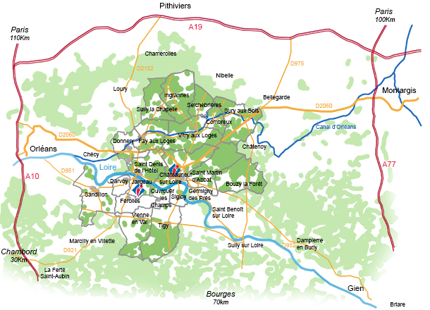


The nearest motorway exits are:
A.10 – exit 14 Orléans Nord
A.19 – exit 7 Pithiviers
– exit 8 Beaune la Rolande
A.6 / A.77 – exit 18 Montargis
A.77 – exit 20 Briare
A.71 – exit 1 Orléans Centre
– exit 2 Olivet
and departmental roads for a quieter journey to us:
RD.2060 Orléans – Montargis
RD.921 Pithiviers – La Ferté Saint Aubin
RD.952 Orléans – Gien
The nearest SNCF train station is Orléans Gare:
timetables, prices, etc. at www.voyages-sncf.com and don’t forget to check your journey at infos-trafic.
The company “Cars Ulys” runs buses from Orléans Gare railway station to various destinations (line 3 for St Denis-Châteauneuf-St Martin / line 7A for Sandillon-Jargeau-Vienne-Tigy / line 17 for Donnery-Fay-Vitry-Sury) :
check timetables, prices and other destinations in the area at www.ulys-loiret.com
See all the different transport links in the region (train, tram, bus, coach, etc.) at www.jvmalin.fr
Orléans-Loiret airportis located in Saint-Denis-de-l’Hôtel, 2 km from Jargeau and 8 km from Châteauneuf-sur-Loire.
Taxis and transport companies can take you from the airport to all towns and villages in our area.